 ASVAB Camp
Learning outcomes and exam alignment
After this lesson, identify Earth's main systems and internal layers, explain how the three rock groups form, distinguish weathering from erosion and deposition, infer major plate-boundary processes, explain basic earthquakes and volcanoes, analyze the water cycle, distinguish weather from climate, and read basic atmospheric and ocean patterns. These are original learning materials for the ASVAB General Science (GS) subtest, which broadly assesses physical and biological science. Exact GS topic weights are not published here; none of these are actual secure ASVAB questions.
Earth is an interacting system
Earth science connects the geosphere (rocks, soil and solid Earth), hydrosphere (liquid and frozen water), atmosphere (surrounding gases), and biosphere (living organisms). Some classifications distinguish the cryosphere as Earth's frozen-water component. These systems exchange matter and energy rather than acting separately. For example, rainfall erodes a mountainside, moves sediment into a river, changes an aquatic habitat, and may influence vegetation. In a scenario question, trace the sequence across more than one system instead of naming only one sphere.
Earth’s interior: crust, mantle, core
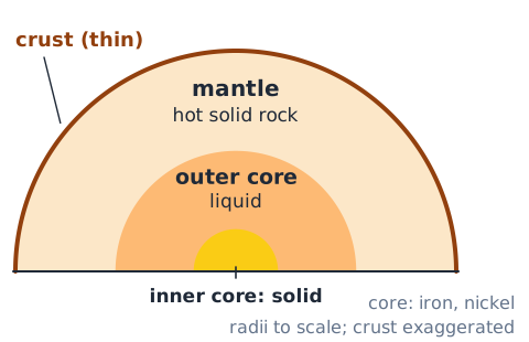
The crust is Earth's thin, solid outermost compositional layer. Below it lies the thick mantle, made mostly of hot solid rock that can deform and flow very slowly over geological time. The core is rich in iron and nickel: the outer core is liquid and the inner core solid under immense pressure. Do not imagine that most of the mantle is a vast ocean of liquid magma. Mantle convection and plate motion involve rock behavior over huge timescales, not everyday liquid circulation.
Lithosphere versus asthenosphere
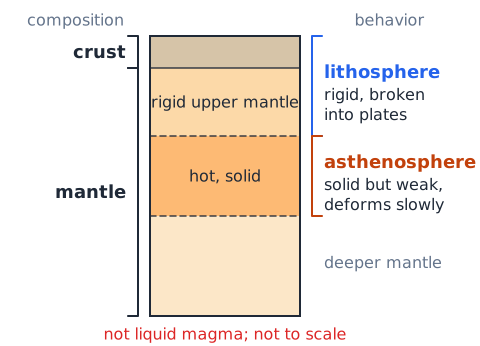
The lithosphere comprises the crust and rigid uppermost mantle, broken into tectonic plates. The hotter asthenosphere beneath is solid but weak enough to deform over time, allowing plate movement. These are mechanical layers, not exactly the same boundaries as the chemical crust–mantle–core divisions. A common test trap says 'plates float on liquid magma'; in reality they move over predominantly solid, slowly deforming mantle. Map each term to whether it describes material composition or material behavior.
Continental and oceanic crust
Continental crust is generally thicker and less dense than oceanic crust, although local compositions vary. Oceanic crust tends to be thinner and denser, with basaltic rocks common. At some convergent margins, denser oceanic lithosphere descends beneath another plate by subduction. Density, age, and the geometry of plates influence the process; do not state that every encounter between two plates automatically produces identical subduction. Relate the density difference to why old oceanic lithosphere can sink.
What tectonic plates are
Tectonic plates are large, rigid pieces of Earth's lithosphere that move slowly relative to one another. Plate motion is measured in small distances per year, commonly millimeters to centimeters per year, yet the accumulated movement reshapes oceans and mountains over millions of years. GPS instruments can measure motion in real time. Earthquakes and volcanoes are common at boundaries, but their exact patterns depend on how plates interact. Don't assume the plates are fixed simply because their everyday movement is imperceptible.
Divergent plate boundaries
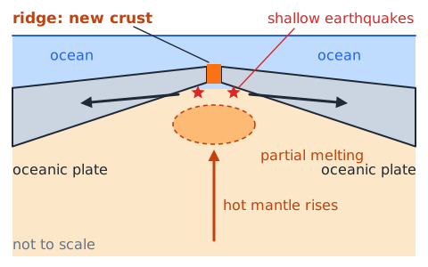
At a divergent boundary, plates separate. Hot mantle material rises and undergoes partial melting in many such settings; magma can make new crust, especially along mid-ocean ridges. The ocean floor spreads away from the ridge. On continents, extension may create rift valleys that can evolve into ocean basins. Earthquakes are typically shallow in spreading environments. A diverging-arrow diagram points to separation, new crust production, and stretching rather than direct plate collision.
Convergent boundaries and subduction
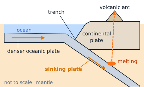
At convergent boundaries, plates move toward one another. Where a denser oceanic plate sinks into the mantle, a trench forms and earthquakes may occur from shallow to great depth. Water released from the descending plate can contribute to melting above it, feeding a volcanic arc. Ocean–continent and some ocean–ocean convergences create such zones. Distinguish the sinking plate from the overriding plate before answering which feature lies where.
Continent–continent convergence
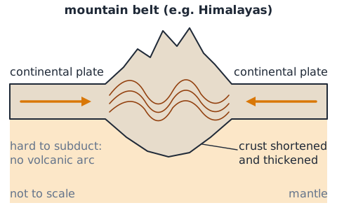
Where two buoyant continental lithospheres collide after an ocean basin closes, extensive crustal shortening and thickening can build high mountain belts. The Himalayas are a classic example. Because continental crust is difficult to subduct deeply in the same way as dense oceanic crust, this setting differs from typical oceanic volcanic arcs. Questions may ask whether mountain building requires a volcanic eruption; tectonic compression alone can raise rock layers enormously over long periods.
Transform boundaries and faults
At a transform boundary, plates slide horizontally past one another. Friction may lock parts of a fault, allowing stress to build until rupture causes an earthquake. Transform motion does not primarily create or destroy oceanic crust. The San Andreas system illustrates strike-slip motion. If a diagram has arrows moving sideways in opposite directions along a boundary, choose transform rather than divergent or convergent; direction of movement is more diagnostic than nearby geographic labels.
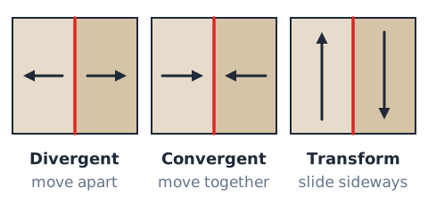
Plate-boundary patterns and exceptions
Most of Earth's earthquakes cluster around plate boundaries, but earthquakes can also occur inside plates on older faults and zones of stress. Volcanoes commonly form near subduction zones or spreading boundaries, but hotspots may generate intraplate volcanoes. Thus 'all earthquakes occur on boundaries' and 'every volcano is at a plate boundary' are wrong. Scientists can assess regional hazards but cannot reliably name the exact time and place of a future large earthquake.
Earthquake focus and epicenter
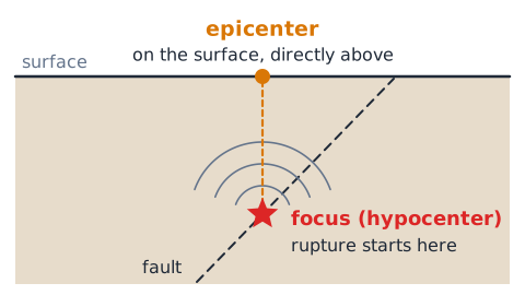
An earthquake's focus, or hypocenter, is the point within Earth where rupture begins. The epicenter is the point on Earth's surface vertically above that focus. Neither is necessarily the location of maximum shaking; ground conditions, distance, depth, and fault rupture also matter. In a cross-section, find the underground star or rupture point for the focus, then project straight upward to identify the epicenter. Keep surface labels distinct from depths.
Magnitude versus intensity
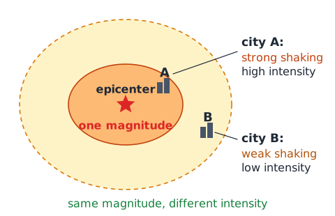
Magnitude is a measure related to the size or energy released by an earthquake and is expressed as one value for a particular event; modern seismic catalogs commonly use moment magnitude for larger earthquakes. Intensity describes how strongly shaking affects a location, and varies across the region. An earthquake can have one magnitude but different intensity ratings in two cities. Avoid confusing magnitude with damage totals, since building quality, soils and distance strongly influence damage.
Seismic wave types
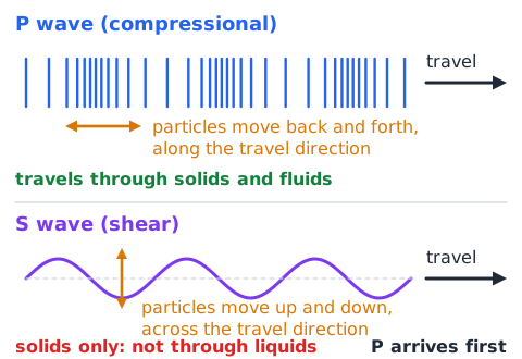
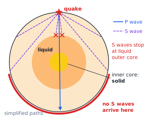
Primary (P) waves are compressional waves and travel through solids and fluids; they normally arrive before secondary (S) waves. S waves are shear waves and do not propagate through liquids. Surface waves move along Earth's surface and can produce damaging motion. The distinction provides evidence about Earth's internal layers: for example, seismic observations of S-wave behavior support the existence of a liquid outer core. Arrival-time questions usually ask which wave reaches a station first.
Earthquake preparedness and what science can say
Engineering design, hazard maps, building codes and drills reduce earthquake risk; they do not prevent tectonic rupture. An earthquake probability estimate for a region and period is not an exact short-term prediction. When answering Earth-science questions, use language that separates a forecast of likelihood from certainty. Tectonic strain can be monitored, but known precursors are not consistently reliable for predicting the day and hour of a major earthquake.
Volcanoes, magma and lava
Magma is molten or partly molten rock beneath the surface; lava is molten rock after it erupts onto the surface. Eruptions may also release gases, ash and fragmented rock. The terms refer to the material's location, not distinct chemical substances. A volcano may erupt effusively with flowing lava or explosively with ash and gas. Viscosity, dissolved gases, composition and other factors influence eruption behavior, so not all volcanoes produce the same kind of eruption.
Hotspots and island chains
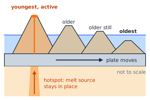
A hotspot is a region of unusually high magmatic activity that may occur away from a plate boundary. As a plate moves over a relatively persistent melt source, a series of volcanoes can form. Older volcanoes may lie farther along the plate's direction of motion, as in the Hawaiian island chain. This is a simplified model and actual mantle sources can shift. In map questions, an age progression across islands is evidence of relative plate movement, not plate immobility.
Minerals are not rocks
A mineral is a naturally occurring solid with a characteristic chemical composition and ordered atomic structure, within the scope of common introductory geology definitions. A rock is a naturally occurring aggregate of one or more minerals or other geological materials. Quartz is a mineral; granite is a rock containing several minerals. A glassy volcanic rock may have few or no crystals. For identifying samples, observe streak, hardness, luster and cleavage rather than assuming every shiny grain is gold.
Mineral hardness and Mohs scale
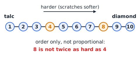
Mohs hardness measures a mineral's resistance to scratching on an ordinal 1–10 scale. Talc is 1 and diamond is 10. A harder mineral can scratch a softer mineral, but the scale is not a linear measure of absolute hardness: a mineral ranked 8 is not necessarily twice as hard as a rank-4 mineral. A scratch test is different from a streak test, which observes the color of mineral powder. Don't confuse hardness with resistance to breaking.
Igneous rock formation
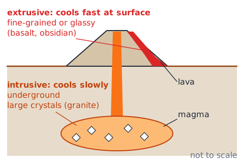
Igneous rock forms when molten material cools and solidifies. Intrusive igneous rocks cool underground and often develop larger crystals because cooling is slower; granite is a common example. Extrusive igneous rocks cool at or near the surface and often have fine-grained or glassy textures; basalt and obsidian are examples. In an identification question, the decisive clue is cooling of magma or lava, not the rock's current location after millions of years of uplift.
Sedimentary rock formation
Sedimentary rocks often begin as sediments deposited by water, wind, ice or gravity. Burial, compaction and cementation can turn loose sediment into solid rock; sandstone is a familiar example. Some sedimentary rocks form from chemical precipitation or accumulated biological material. Layers and fossils are common clues, though not universal. The critical sequence is deposition followed by lithification; heating rock until it melts makes igneous, not sedimentary, material.
Metamorphic rock formation
Metamorphic rock forms when an existing rock changes in the solid state due to elevated temperature, pressure and chemically active fluids. The rock does not need to melt. Limestone can become marble, and shale can become slate under suitable conditions. Foliation is an aligned or banded texture that develops in some metamorphic rocks, but not all. If an exam stem says rock recrystallizes without melting under heat and pressure, the answer is metamorphism.
The rock cycle has multiple paths
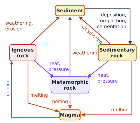
The rock cycle is a set of processes, not a fixed one-way loop. Any exposed rock can weather into sediment. A buried rock can undergo metamorphism; rocks may melt, and the resulting magma can cool into igneous rock. Sedimentary rocks may become metamorphic without first becoming igneous. The pathways are powered by Earth's internal heat, tectonic processes and surface energy from sunlight and gravity. Read arrow labels on a diagram rather than memorizing one circular order.
Weathering breaks material down in place
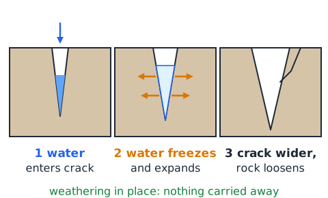
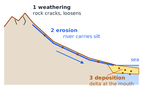
Weathering changes rocks at or near Earth's surface without requiring the broken material to be carried away. Mechanical weathering includes freeze–thaw cracking, abrasion and root wedging. Chemical weathering alters minerals through reactions such as dissolution or oxidation. Water entering a crack, freezing and expanding is weathering at that location. If the prompt states that particles are carried downstream, the process has advanced to erosion or transport.
Erosion transports; deposition settles
Erosion removes and transports weathered material through running water, wind, ice or gravity. Deposition occurs when that transported material settles, often as the transporting medium loses energy. A river carrying silt is an example of transport; a delta growing from sediment settling near a river mouth illustrates deposition. An exam may present all three stages in one sentence: weathering makes loose material, erosion moves it, and deposition leaves it somewhere new.
Physical versus chemical weathering
Mechanical or physical weathering breaks rock into smaller pieces without changing the mineral composition itself; repeated thermal expansion and frost wedging are examples. Chemical weathering changes the chemical makeup of minerals; mildly acidic rainwater dissolving calcite in limestone is one example. The processes can reinforce each other because cracks create more surface area for chemical reactions. Do not confuse acid dissolution with mere sediment transportation; it changes material chemistry.
Soil forms through interacting processes
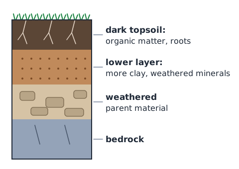
Soil develops from weathered parent material mixed with organic matter, water, air and living organisms. Climate, organisms, relief, parent material and time influence soil development. Horizons may differ in organic material, clay and weathered minerals. Dark topsoil commonly contains decomposed organic matter and supports roots, but fertility varies widely. Soil formation can be slow compared with rapid erosion, so vegetation loss can increase long-term land degradation.
Mass wasting and slope stability
Mass wasting is the downslope movement of soil, sediment or rock primarily under gravity. Rockfalls, landslides and debris flows are examples. Heavy rainfall may increase pore-water pressure and weaken a slope, while excavation, earthquakes and vegetation loss can also contribute. Gravity is the ultimate driving force even if rain triggers an event. In a cause-and-effect question, distinguish the trigger from the force that moves material downhill.
Fossils and sedimentary layers
Fossils are preserved traces or remains of organisms and are most commonly found in sedimentary rocks, where material may be buried without exposure to high temperatures and pressures. Sedimentary layering helps reconstruct environments. In an undisturbed sequence, the principle of superposition says lower layers are generally older than layers above them. Folding, faulting or overturning may complicate that pattern, so the principle is applied with geological context rather than as an unconditional rule.
Relative versus absolute dating
Relative dating orders geological events as older or younger without assigning an exact number of years. Cross-cutting relationships show that a fault or intrusion is younger than a rock body that it cuts. Radiometric dating uses predictable radioactive decay in suitable minerals to estimate numeric ages. A half-life is the time for half the radioactive parent atoms in a closed sample to decay; it does not mean all atoms decay in two half-lives.
Earth’s freshwater and saltwater
Most of Earth's water is saline and held in oceans. Freshwater is a much smaller fraction, much of it stored as ice or groundwater, with relatively little in rivers and lakes at any moment. Water availability depends on its form, location, quality and rate of replenishment. A test may contrast total water on Earth with readily accessible freshwater: an abundant ocean does not imply plentiful drinkable freshwater without treatment or desalination.
Solar energy and gravity drive the water cycle
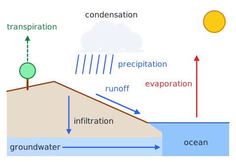
Water moves among the oceans, atmosphere, land, ice and underground reservoirs. Sunlight supplies energy that drives evaporation; gravity helps precipitation fall, streams flow downhill and water infiltrate through soil. No single step is the permanent beginning of the cycle. The water molecule can spend long periods in a storage reservoir before moving again. Correct diagrams can show multiple loops rather than a single simple ocean-cloud-rain arrow.
Evaporation and transpiration
Evaporation converts liquid water to vapor at a surface, including lakes and moist soil. Transpiration is the movement of water through plants followed by water-vapor release, typically through leaf stomata. Their combined contribution is called evapotranspiration. Both supply atmospheric water vapor, though the importance of each varies with place and conditions. Water vapor is an invisible gas; a visible cloud is mostly tiny droplets or ice crystals, not 'visible steam' alone.
Condensation and cloud formation
As humid air rises and cools, water vapor may condense on tiny airborne particles into liquid droplets, or under some conditions form ice. Condensation releases latent heat to the surrounding air. Clouds consist of droplets, ice crystals, or both, and their presence does not guarantee precipitation at the surface. For rainfall, cloud particles must grow enough to fall and survive the trip through the air below. A wet outside surface on a cold glass is a familiar condensation example.
Precipitation and the form of falling water
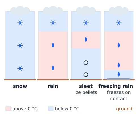
Precipitation includes rain, snow, sleet and hail, depending on cloud microphysics and the temperatures through which particles fall. Snow can melt into rain in warm layers; a freezing layer near the ground can alter the final precipitation type. Sleet and freezing rain are not the same: one is ice pellets, while the other freezes on contact with cold surfaces. Test questions often give a temperature profile rather than merely asking for a definition.
Runoff, infiltration and groundwater
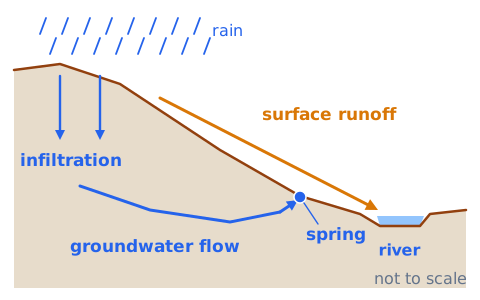
Surface runoff is water moving across land toward channels, lakes or the sea. Infiltration is water entering the ground; percolation can carry it deeper through pores and fractures. Groundwater occupies saturated spaces underground and may flow slowly toward springs, streams and wells. It is usually not an open subterranean river. Paved surfaces often reduce infiltration and increase rapid runoff, helping explain why intense storms can produce flash flooding in developed watersheds.
Aquifers, water table and recharge
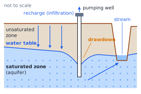
An aquifer is a permeable geological unit that can store and transmit enough groundwater to be useful. The water table is the upper boundary of the saturated zone in an unconfined aquifer. Recharge adds water to groundwater stores, often through infiltration and percolation. A well's drawdown can lower groundwater levels locally. Groundwater is not invariably a renewable resource on a human timescale: some aquifers recharge far more slowly than pumping removes water.
Watersheds and drainage basins
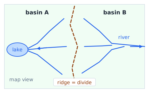
A watershed, or drainage basin, is an area of land in which precipitation and runoff drain toward a common waterway, lake or outlet. Ridges form divides separating neighboring basins. Pollution spilled upstream may be transported into downstream streams and reservoirs, depending on flow paths and treatment. When reading a map, follow downhill drainage and dividing ridgelines rather than assuming nearby locations share a water supply. Watershed management considers soils, vegetation and land use together.
Weather versus climate
Weather describes short-term atmospheric conditions at a specific time and location: temperature, clouds, rain, wind and air pressure. Climate describes long-term patterns, variability and averages of weather across an area, typically assessed over decades. A rainy day does not establish a wet climate, and a winter cold spell does not by itself disprove long-term warming trends. Questions often contrast today's forecast with a 30-year regional average; classify them by timescale and statistics.
Composition and structure of the atmosphere
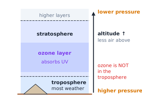
Dry air near the surface is mainly nitrogen and oxygen, with smaller amounts of argon and carbon dioxide; water-vapor concentration varies. The troposphere is the lowest main atmospheric layer and contains most everyday weather. The stratosphere lies above and contains the ozone layer, which absorbs much incoming ultraviolet radiation. Temperature changes with height differently in different layers. Don't claim the ozone layer is in the troposphere or that air pressure is constant with altitude.
Air pressure and altitude
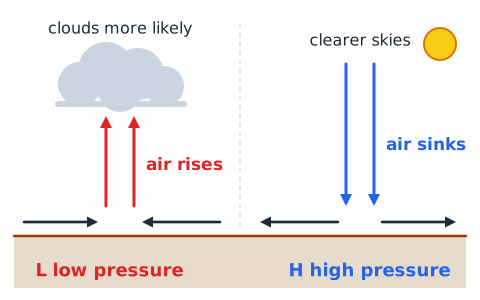
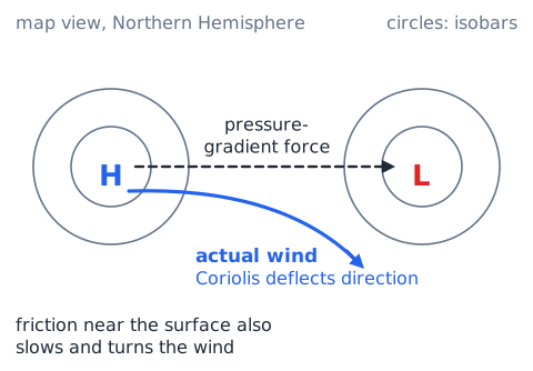
Air pressure arises from the weight of the atmosphere above an area. It generally decreases with increasing altitude because there is less air overhead. Weather maps often show pressure patterns using isobars, lines connecting equal pressure. Rising air tends to be associated with surface low-pressure systems and greater potential for clouds; sinking air often accompanies surface high pressure and clearer conditions, though local outcomes depend on moisture and weather dynamics.
Why wind moves
Differences in solar heating lead to temperature and pressure differences that can drive air motion. Air experiences a pressure-gradient force, while Earth's rotation deflects large-scale motion through the Coriolis effect. Surface friction also affects direction and speed. Air doesn't always flow straight from a high to a low on a weather map because these forces act together. The Coriolis effect changes direction, not the energy source of atmospheric circulation.
Warm and cold fronts
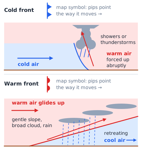
A front separates contrasting air masses. Along a cold front, advancing cold air can force warmer air upward relatively abruptly, favoring showers or thunderstorms when moisture and instability are present. At a warm front, warm air commonly glides above retreating cooler air and can produce broader cloud and precipitation areas. These are typical patterns rather than guarantees. Examine the air-mass motion and frontal symbol instead of inferring conditions from the label alone.
Humidity, dew point and relative humidity
Humidity concerns water vapor in air. Dew point is the temperature to which air must be cooled at constant pressure and water-vapor content to reach saturation with respect to liquid water. Relative humidity expresses actual water-vapor pressure compared with saturation vapor pressure at that temperature; it changes as temperature changes even if moisture content does not. Air near its dew point may allow fog or dew to form. A high relative humidity does not automatically mean more absolute water vapor than warmer air with lower relative humidity.
Thunderstorms, lightning and tornadoes
Thunderstorms develop when moist air rises and becomes unstable, forming deep convective clouds. Lightning is an electrical discharge caused by charge separation within storms, and thunder results from rapid heating and expansion of air. Tornadoes are violently rotating columns of air connected to storm clouds and the surface; many form in powerful rotating thunderstorms, but not all thunderstorms produce tornadoes. Strong winds, hail and flash floods can be hazardous even without a tornado.
Tropical cyclones and energy sources
Hurricanes are tropical cyclones in certain ocean basins, fueled by warm ocean water and moisture that support deep convection; the release of latent heat helps sustain circulation. Sufficient Coriolis influence is needed for typical large-scale rotation, so these systems rarely form exactly at the equator. Major dangers include storm surge, wind and inland flooding. A hurricane's category chiefly represents wind strength and does not summarize all flood risk or storm size.
Greenhouse effect and Earth’s energy balance
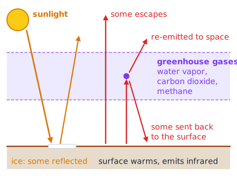
Earth absorbs some incoming sunlight and emits infrared radiation. Greenhouse gases including water vapor, carbon dioxide and methane absorb and emit infrared radiation, influencing how energy escapes to space. The natural greenhouse effect keeps the surface warmer than without those gases; increasing concentrations of long-lived greenhouse gases can alter the energy balance and warm the climate. A greenhouse gas need not trap all radiation, and clouds, oceans and ice also affect the balance.
Ocean surface processes and currents
Oceans store and transport huge amounts of heat. Surface currents are strongly influenced by winds, Earth rotation and the shapes of ocean basins. Deep circulation is affected by water-density differences related to temperature and salinity, among other processes. Warm and cold currents can change nearby coastal climate, although local wind and topography also matter. Ocean waves are often generated by wind; they are not identical to steady ocean currents or the periodic tidal rise and fall.
Tides, moon and sun
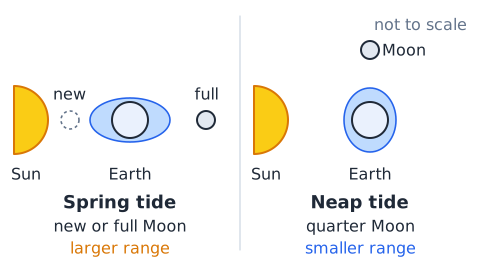
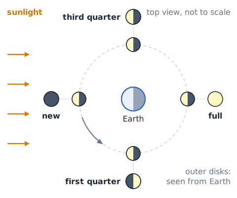
Tides are regular, periodic rises and falls in sea level caused primarily by differential gravitational effects of the Moon, with a significant contribution from the Sun. Tidal patterns vary by basin shape and coastline. Near new and full moons, the Sun and Moon align more strongly in their tidal effects, producing spring tides with larger range; around first and third quarter phases, neap tides generally have smaller range. 'Spring' here does not mean the season spring.
Day, year and seasons
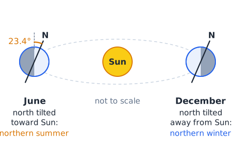
Earth's rotation relative to the Sun produces the familiar daily cycle of daylight and night, while revolution around the Sun takes roughly one year. The primary cause of seasons is Earth's axial tilt of about 23.4 degrees, which changes Sun angle and daylight duration over the year. The Northern and Southern Hemispheres have opposite seasons. Earth–Sun distance varies somewhat through the year but is not the main cause of the ordinary seasonal cycle.
The Moon, phases and eclipses
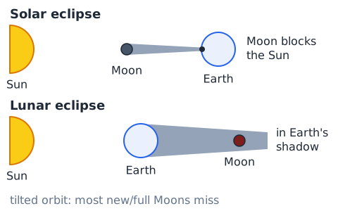
Moon phases arise because we view different fractions of the Moon's sunlit half as its position changes around Earth. The Moon does not produce its own visible light. A lunar eclipse occurs when Earth's shadow falls on the Moon; a solar eclipse occurs when the Moon blocks sunlight for an observer on Earth. Eclipses do not happen at every new or full Moon because the Moon's orbital plane is tilted relative to Earth's orbital plane.
Common Earth science graph skills
A line graph of monthly average temperature shows how a climate measure changes with time; a short list of today's hourly temperatures describes weather. A map with earthquake dots often reveals belts along plate boundaries, not a perfect one-to-one boundary detector. A pie chart showing ocean water as the largest category uses percentages of all water, not percentages of drinkable freshwater. Before calculating, read the axes, units, date range and legend.
Rates and simple distance calculations
Science questions sometimes combine a geological concept with basic arithmetic. A hypothetical plate moving at 3 centimeters per year travels 30 centimeters in 10 years if that rate remains constant. Convert units before reporting: 100 centimeters = 1 meter. A stream delivering 600 liters over 5 minutes has a mean flow rate of 120 liters per minute. These are simplified constant-rate scenarios; real plate speeds and water flows vary over place and time.
Evidence and scientific limits
A scientific conclusion should match the evidence collected. A fossil sequence can support the order of events but may not supply an exact age without additional dating evidence. Earthquake hazard mapping estimates susceptibility, not exact future dates. Climate is measured through long-term data, not one extreme day. Treat models as useful simplifications; a drawing of the rock or water cycle may leave out real pathways. Ask whether the claim describes an observation, plausible mechanism, or unsupported certainty.
Three rock groups
A sample formed by cooling magma under Earth’s surface. Which group? Igneous: cooling of molten material is the defining clue. If a different rock changed without melting due to pressure, metamorphic would be correct. If sediments were compacted and cemented, sedimentary would be correct. Identify the defining observation first, then reject answers that rely on the wrong process or time scale. The example is an original instructional scenario, not a live ASVAB item.
Follow the water through a watershed
Rain falls on a hill. Part runs into a river; part soaks into soil and later emerges at a spring. Label the paths: surface runoff reaches the river; infiltration followed by groundwater movement produces the spring. Neither path requires water to disappear. Identify the defining observation first, then reject answers that rely on the wrong process or time scale. The example is an original instructional scenario, not a live ASVAB item.
Interpret plate arrows
A diagram shows arrows pointing away from a central ocean ridge. This is a divergent plate boundary. The expected features are seafloor spreading, new oceanic crust and mostly shallow earthquakes, not continent–continent collision. Identify the defining observation first, then reject answers that rely on the wrong process or time scale. The example is an original instructional scenario, not a live ASVAB item.
Locate earthquake focus
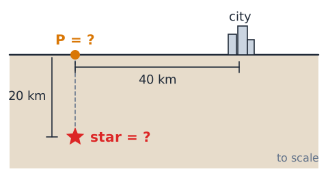
A star marking the rupture sits 20 km underground, while point P is directly above on the surface. The star is the focus (hypocenter); P is the epicenter. A surface city 40 km away is neither automatically the epicenter nor the location of maximum shaking. Identify the defining observation first, then reject answers that rely on the wrong process or time scale. The example is an original instructional scenario, not a live ASVAB item.
Compute plate displacement
An idealized plate moves 4 cm/year. Over 25 years the displacement is
= 1 m. Real rates vary, but dimensional units show why slow movement produces large geological changes over long durations. Identify the defining observation first, then reject answers that rely on the wrong process or time scale. The example is an original instructional scenario, not a live ASVAB item.
Choose between weathering and erosion
Rainwater chemically dissolves exposed limestone at its location: weathering. The same water carries dissolved and suspended material downstream: transport or erosion. At the river mouth, sand settles and accumulates: deposition. More than one process can appear in one story. Identify the defining observation first, then reject answers that rely on the wrong process or time scale. The example is an original instructional scenario, not a live ASVAB item.
Half-life without a calculator
A sample begins with 80 units of a radioactive parent isotope. After two half-lives in an ideal closed system, 80 → 40 → 20 units remain, or 25% of the starting amount. Two half-lives do not reduce the sample to zero. Identify the defining observation first, then reject answers that rely on the wrong process or time scale. The example is an original instructional scenario, not a live ASVAB item.

Read humidity language
An outdoor forecast reports 90% relative humidity one morning and 50% during a warmer afternoon. That alone does not prove water vapor was removed from the air; relative humidity depends on temperature. Dew point offers another clue about moisture amount. Identify the defining observation first, then reject answers that rely on the wrong process or time scale. The example is an original instructional scenario, not a live ASVAB item.
Air-mass front analysis
A cold air mass advances into warm humid air. Where the warmer air rises rapidly, cumulonimbus clouds and heavy showers may develop. Identifying the cold front does not guarantee thunderstorms, because instability and moisture also matter. Identify the defining observation first, then reject answers that rely on the wrong process or time scale. The example is an original instructional scenario, not a live ASVAB item.
Seasonal reasoning
On a June date, the Northern Hemisphere is tilted more toward the Sun. Longer daylight and a higher average Sun angle produce northern summer; the Southern Hemisphere experiences winter. The difference is not mainly because Earth is closer to the Sun in June. Identify the defining observation first, then reject answers that rely on the wrong process or time scale. The example is an original instructional scenario, not a live ASVAB item.
Water flow rate
A drainage pipe carries 450 liters of water in 9 minutes at a constant average rate. The rate is
per minute. Check that the requested unit is volume per time, rather than the volume or duration alone. Identify the defining observation first, then reject answers that rely on the wrong process or time scale. The example is an original instructional scenario, not a live ASVAB item.
Tidal range
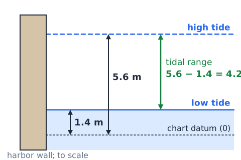
At one harbor, the water level is 5.6 meters at high tide and 1.4 meters at low tide relative to the same chart datum. The tidal range is
never add these heights when computing a difference. Identify the defining observation first, then reject answers that rely on the wrong process or time scale. The example is an original instructional scenario, not a live ASVAB item.
Cross-cutting relationship
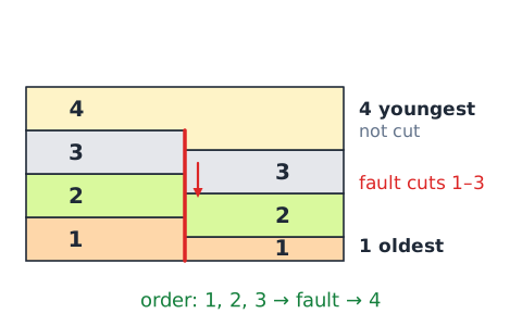
A vertical fault cuts across three sedimentary layers and is itself covered by an undisturbed fourth layer. The fault movement occurred after the three cut layers formed but before the overlying undisturbed fourth layer was deposited. This establishes relative order, not numeric ages. Identify the defining observation first, then reject answers that rely on the wrong process or time scale. The example is an original instructional scenario, not a live ASVAB item.
Compare climate and weather
“The city had rain Tuesday” is weather. “Rainfall averages 900 mm per year over 30 years” is climate. The timescale and statistic—not whether the statement mentions rain or temperature—determine the correct category. Identify the defining observation first, then reject answers that rely on the wrong process or time scale. The example is an original instructional scenario, not a live ASVAB item.
Drill 1: Earth layers
Without notes, name Earth’s compositional layers from outside inward, then state whether the mantle is mainly a global molten ocean. Expected: crust, mantle, core; mantle is predominantly solid, capable of slow deformation. Explain why the lithosphere includes crust and uppermost mantle instead of matching the crust alone. Check your response against the explained examples above and rewrite any answer that confuses a cause with a consequence.
Drill 2: Boundary map
Draw three small boxes with two arrows in each: apart, together, sideways. Label divergent, convergent and transform. Add one realistic feature: mid-ocean ridge, trench or mountain belt, and strike-slip fault respectively. For convergence, state the plate types when predicting subduction. Check your response against the explained examples above and rewrite any answer that confuses a cause with a consequence.
Drill 3: Rock processes
For each action classify the main step: lava solidifies, loose sand cements, limestone recrystallizes under heat without melting, granite breaks in place, sediment enters a river and deposits in a delta. Answers: igneous, sedimentary, metamorphic, weathering, erosion/transport and deposition. Check your response against the explained examples above and rewrite any answer that confuses a cause with a consequence.
Drill 4: Complete water cycle
Use these words in a valid sequence: evaporation, condensation, precipitation, infiltration, groundwater flow, river runoff. Draw an alternate branch from falling rain to runoff. Explain why the water cycle is not a strict fixed-order list and why groundwater can reenter surface streams. Check your response against the explained examples above and rewrite any answer that confuses a cause with a consequence.
Drill 5: Interpret weather data
Compare hourly pressure dropping as clouds thicken with a region’s 30-year mean rainfall. The former is a weather trend, while the latter is climate. State why neither trend alone proves that a specific hurricane will strike and identify another variable affecting precipitation. Check your response against the explained examples above and rewrite any answer that confuses a cause with a consequence.
Drill 6: Apply astronomy to Earth
Describe a June solstice using axial tilt, sunlight angle and length of day in the Northern Hemisphere. Then name the lunar phase associated with a typical spring tide. Responses: north-tilted summer conditions and new/full Moon alignments; do not confuse tide naming with seasons. Check your response against the explained examples above and rewrite any answer that confuses a cause with a consequence.
Six exam traps to avoid
(1) Plates do not travel over a worldwide ocean of liquid mantle. (2) Most earthquakes occur at plate boundaries, but not all. (3) Weathering breaks down in place, erosion transports and deposition settles. (4) Rock-cycle diagrams allow multiple pathways, not only a fixed three-step loop. (5) A single day's weather is not a climate average. (6) The seasons are primarily caused by axial tilt, not changes in Earth–Sun distance. Underline absolutist distractors such as 'always' and 'only' and check whether the underlying mechanism supports them.
ASVAB GS problem-solving strategy
For each multiple-choice item, identify what kind of evidence is given: process description, map, timing, measurement or numerical rate. Translate verbs into mechanisms—'cools from molten' for igneous, 'compresses sediment' for sedimentary, 'without melting under pressure' for metamorphic. On computation items, write units and use simple arithmetic without relying on a calculator. Official GS covers broad science; the 40-question practice test here is a learning assessment, not the operational GS item count or time limit.
Key takeaways and next-step mastery check
Earth systems exchange matter and energy; the lithosphere moves as plates over a deformable mantle. Convergence, divergence and transform motion shape faults, volcanoes and mountains. Rocks cycle through cooling, deposition, lithification, metamorphism and sometimes melting. Weathering acts in place; erosion transports; deposition settles. Solar energy and gravity drive the water cycle. Weather is short-term, climate long-term. Atmospheric circulation reflects uneven heating. Earth’s axial tilt creates seasons, and lunar–solar tidal forcing shapes ocean tides. You should now explain each mechanism aloud and solve the lesson quiz without memorizing only word pairs.
 English ▾